Dr. Subhasis Ghosh
Assistant Professor of Physical Geography
Dept. of Chemistry and Geosciences,
Jacksonville State University
Jacksonville, Alabama, United States, 36265
about
"Dedicated to excellence, committed to impact"

Besides academics, he is actively engaged in various leadership, community service, and outreach activities within and off campus. At present, he serves as the Vice Chair of the Regional Development and Planning Specialty Group of the American Association of Geographers (AAG). He enjoys mentoring students and helping them discover their true potential.
View Scholarly Profiles:
Google Scholar , ORCID, Research Gate
recent publications
"Discover, Explore, Engage!"
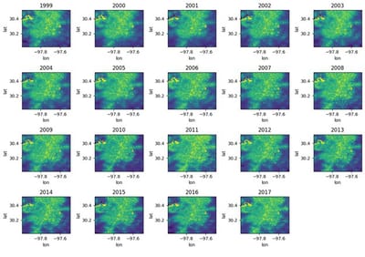
NDUI+: A New AI-powered multidecadal global high-resolution urban dataset is here! check it out!
The all-new NDUI+ dataset is a global, high-resolution (30-meter) remotely sensed urban dataset, covering the period from 1999 to the present. It solves key challenges in remote sensing, including gaps in resolution, coverage, and the continuity of urban data. This comprehensive dataset is valuable for a wide range of applications, such as urban growth analysis, microclimatic variability studies, and assessments of economic impacts, among others. NDUI+ data can be generated globally using the codes made available at https://github.com/manmeet3591/ndui_plus, and the trained weights available in Zenodo.
Read More
Have covid lockdowns really improved global air quality? –Hierarchical observations from the perspective of urban agglomerations using atmospheric reanalysis data
COVID-19 cases surged in late 2019, leading to worldwide lockdowns that closed non-essential places and activities, industries, and businesses to halt the spread of the virus. Many studies suggested improved air quality during lockdowns. However, these findings often focused on core city limits and did not account for heavy pollution sources outside cities (around the fringe areas), such as factories, power plants, and coal mines, which operated continuously for energy needs even during lockdowns. Therefore, this study quantified and re-analyzed the air quality data using a top-down approach.
Read More
NDUI+: A fused DMSP-VIIRS based global normalized difference urban index dataset (Preprint, under review with Nature Cities)
Urbanization is advancing rapidly, covering less than 2% of Earth's surface yet profoundly influencing global environments and experiencing disproportionate impacts from extreme weather events. Effective urban management and planning require high-resolution, temporally consistent datasets that capture the complexity of urban growth and dynamics. This study presents NDUI+, a novel global urban dataset addressing critical gaps in urban data continuity and quality. NDUI+ integrates data from the Defense Meteorological Satellite Program's Operational Linescan System (DMSP-OLS), VIIRS Nighttime Light, and Landsat 7 NDVI using advanced remote sensing and deep learning techniques. The dataset resolves sensor discontinuity challenges, offering a seamless 30-meter spatial and annual temporal resolution time series from 1999 to the present. NDUI+ demonstrates high precision and granularity, aligning closely with high-resolution satellite data and capturing urban dynamics effectively. The dataset provides valuable insights for urban climate studies, IPCC assessments, and urbanization research, complementing resources like UT-GLOBUS for urban modeling.
Read More
Biogeographic Distribution of Cedrela spp. Genus in Peru Using MaxEnt Modeling: A Conservation and Restoration Approach
The increasing demand for tropical timber from natural forests has reduced the population sizes of native species such as Cedrela spp. because of their high economic value. To prevent the decline of population sizes of the species, all Cedrela species have been incorporated into Appendix II of the Convention on International Trade in Endangered Species of Wild Fauna and Flora (CITES). The study presents information about the modeled distribution of the genus Cedrela in Peru that aims to...
Read More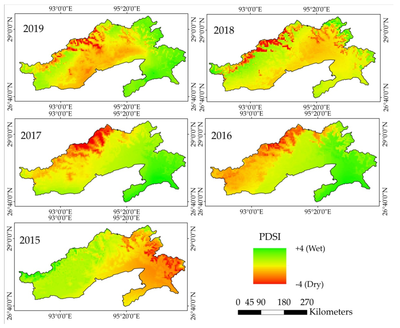
Long-Term Sensitivity Analysis of Palmer Drought Severity Index (PDSI) Through Uncertainty and Error Estimation from Plant Productivity and Biophysical Parameters
Palmer Drought Severity Index (PDSI) is the most effective and well-acknowledged drought severity index that particularly determines the long-term drought conditions over the forest and other terrestrial ecosystems. However, the sensitivity of PDSI has not been explored yet based on productivity (i.e., Gross Primary Productivity (GPP)), biophysical parameters (i.e., biomass—Leaf Area Index (LAI) and Enhanced Vegetation Index (EVI) and greenness content—Normalized Difference Vegetation Index (NDVI)), and absorbed solar radiation by plants (i.e., fraction of Absorbed Solar Radiation (fAPAR)) over a humid-subtropical forest ecosystem...
Read More
Environmental Risk Assessment: A Geomorphic Investigation over the Bolpur-Santiniketan-Illambazar Lateritic Patch of Birbhum District, West Bengal, India
A proper Geomorphic study of a region can be useful in understanding past and present environmental circumstances and analyzing potential environmental risks. Careful analysis of morphodynamic processes and existing diagnostic land forms reveal several aspects about the origin, characteristics and possible pattern of morpho-climatic interactions on the landscape over temporal scale, which helps significantly in proper terrain evaluation from societal welfare and integrated management point of view, including environmental risk assessment and disaster management. This paper has made a thorough geomorphic investigation...
Read More
Canopy Scale High-Resolution Forest Biophysical Parameter (LAI, fAPAR, and fCover) Retrieval Through Machine Learning and Cloud Computation Approach
High-resolution Forest biophysical parameter estimation is crucial to understand forest structural and functional variability. Moreover, mapping high-resolution biophysical products is significant to capture accurate forest carbon fluxes and understand seasonal variability. The existing biophysical products are coarse in spatial resolution and unable to capture intra-annual variability. In this study, we proposed a random forest machine learning approach embedded in Google Earth Engine to retrieve three major forest biophysical parameters. The training samples were distributed in a 70:30 ratio for model training and validation. The outcome of the work shows promising results that hold a good agreement with SNAP-derived biophysical variables, whereas the agreement is moderate-to-poor for MODIS and VIIRS biophysical products...
Read Moremedia spotlight
"Shining Bright in Media's Spotlight!"
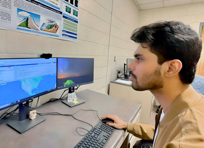
Auburn doctoral student challenges perceptions of COVID-lockdowns' impact on air quality with international team of researchers through NASA project
Research activity featured by COSAM Today news
Read Moreexperience
"Where knowledge meets action"
Assistant Professor of Physical Geography
Graduate Teaching Assistant
Teaching Assistant at the Department of Geosciences, Auburn University, USA. Courses Teaught: Advanced GIS, Drones and Geospatial Applications, Quantitative Methods and Spatial Analysis, Concepts of Science, Global Geography.
Graduate Research Assistant (USGS funded project)
Working in a USGS-funded project - 'Earth as Art’ Interactive Global Museum. In this project, I am turning the complex remote-sensing images into simple, artistic photographs and working with a multidisciplinary team to transform the processed images into engaging virtual reality (VR) based interactive modules, ensuring alignment with educational objectives and target audience engagement to promote interest in Earth science and STEM disciplines.
Graduate Research Assistant - NASA IDS
Researching the impacts of global urbanization footprints and urban rainfall effect climatologies funded by National Aeronautics and Space Administration (NASA)At Department of Geosciences, Auburn University Duration: Aug 2021 to Present
Project Scientist at West Bengal State Council of Science & Technology, Govt. of West Bengal, India
Professionally worked and contributed to the project- “Space Based Information Support for Decentralized Planning (SIS-DP) Update”, sponsored by National Remote Sensing Centre (NRSC), Indian Space Research Organization (ISRO), Govt. of India. Duration: Mar 2021 - Jul 2021
Trainee GIS Analyst at Prayukti Systems Private Limited, India
Engaged as the Lead GIS Consultant to the office of West Bengal State Rural Development Agency - Purulia Division, Govt. of West Bengal for the project - ’Utility-Facility mapping, geo-database creation, and verification of road construction status sanctioned under Pradhan Mantri Gram Sadak Yojana (PMGSY) scheme' , funded by Government of India.
view or download cv
"Get a snapshot of my skills and accomplishments"
testimonials
contact
"Let's Connect!"
- 400 Pelham Road North
- Office: 211 Martin Hall, Dept. of Chemistry and Geosciences, Jacksonville State University, Jacksonville, Alabama, 36265.
info@subhasisghosh.com
